This quick started guide assumes the setup page is read and the environment is prepared. The complete source code is in github.
In the previous quick start guide for service, we setup a tiled map service by accessing map tiles by XYZ standard. This guide, we will continue working on this project to add client code to build an interactive map.
User Story
For a software development, defining the user story is the first thing. Our quick started user story is this.
I need a B/S map software with a map that can pan, zoom and allows to show me the detail information where I clicked.
Let’s Get Started
A web application could be two ways. one is completely backend and frontend separated (e.g. client + RESTful); another one is to to render the HTML pages on the server part (e.g. express.js + templates). In this guide, I will use the former one. For we could reuse our existing services, and our project could be cleaner structural.
Prepare The Project Baseline
Let’s prepare the project baseline. Assume our previous quick start for service is completed and folder name is quick-started-service. We will reuse the code in this project.
1
2
3
4
5
# copy the previous project as our current quick start project baseline
cp -r quick-started-service quick-started-web
cd quick-started-web
yarn
code .
Now, we have the project baseline and opened this project with visual studio code.
Build an Initial Map View
Create a folder client and a file index.html inside.
NOTE: this is also from Leaflet quick start tutorial with the map service URL replaced, http://localhost:5500/maps/default/{z}/{x}/{y}. The attribution is replaced as well 😎.
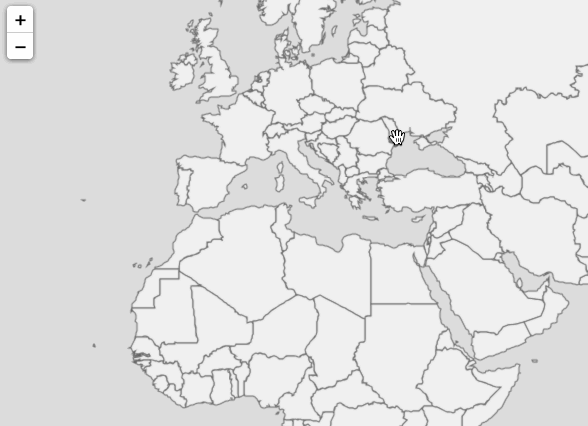
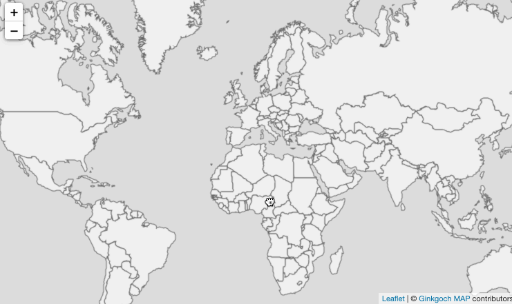
Now we can launch our server by node index.js and drag the client/index.html into browser. An initial map view will be represented in front of you.
Refactor the Code for More APIs
Now, we are going to add more APIs (e.g. identify) on this HTTP server. Let’s refactor the code as following.
Basically, three changes are straight forward.
Extract a function to get the MapEngine instance.
Extract a function for serving XYZ tile service.
Handle the route handlers in a loop.
Don’t be afraid to refactor, it seems more code, but it also makes it extensible and re-usable, less code for future features.
// register native graphics and it is the most important one require('ginkgoch-map/native/node').init();
const port = 5500; functionserve() { const server = http.createServer(async (req, res) => { let handled = false; // handle the route handlers in a loop. let routeHandlers = [handleTileRoute]; // new route handlers will be added in this array later for (let routeHandler of routeHandlers) { handled = await routeHandler(req, res); if (handled) { break; } }
if (!handled) { console.debug(`URL not handled: ${req.url}`); } });
server.listen(port, () => { console.log(`Server is served at http://localhost:${port}`); }); }
asyncfunctiongetTileImage(x, y, z) { let mapEngine = getMap(); let mapImage = await mapEngine.xyz(x, y, z); return mapImage.toBuffer(); }
// extract a function to get the `MapEngine` instance. functiongetMap() { let sourcePath = path.resolve(__dirname, `../data/cntry02.shp`); let source = new G.ShapefileFeatureSource(sourcePath); let layer = new G.FeatureLayer(source); layer.styles.push(new G.FillStyle('#f0f0f0', '#636363', 1)); let mapEngine = new G.MapEngine(256, 256); mapEngine.pushLayer(layer); return mapEngine; }
// extract a function for serving XYZ tile service. asyncfunctionhandleTileRoute(req, res) { let handled = false;
// parse the route: /maps/default/{z}/{x}/{y} if (req.url.match(/maps\/default(\/\d+){3}/)) { // parse x, y, z from url let segments = req.url.split('/'); let [z, x, y] = segments.slice(segments.length - 3);
// draw tile image let tileImage = await getTileImage(x, y, z);
Identify allows to find regions of a map within a specified distance of one or more features. It is a basic spatial analysis operation.
Assume our new API is GET: /maps/default/{layerName}/query also the clicked information is included in query string. e.g. GET: /maps/default/{layerName}/query?lat=0&lng+0&zoom=0 will find the features around longitude 0, latitude 0 under zoom level 0 (of course there is no features around there).
// handle the identify route asyncfunctionhandleIdentifyRoute(req, res) { let handled = false;
// parse the route: /maps/default/{layerName}/query if (req.url.match(/maps\/default\/\w+\/query/ig)) { let parameters = parseIdentifyParameters(req); let features = await getIdentifyFeatures(parameters); let featureCollection = new G.FeatureCollection(features) res.end(JSON.stringify(featureCollection.toJSON())); handled = true; }
return handled; }
asyncfunctiongetIdentifyFeatures(parameters) { let projection = new G.Projection('WGS84', 'EPSG:3857'); let clickedPoint = new G.Point(parameters.lng, parameters.lat); clickedPoint = projection.forward(clickedPoint);
let mapEngine = getMap(); let layer = mapEngine.layer('cntry02'); if (layer === undefined) { return []; }
await layer.open(); let features = await layer.source.query('intersection', clickedPoint); features.forEach(f => f.geometry = projection.inverse(f.geometry)); return features; }
functionparseIdentifyParameters(req) { let queryStringStarts = req.url.lastIndexOf('?'); let lat = undefined, lng = undefined, zoom = undefined; if (queryStringStarts !== -1) { let queryString = req.url.slice(queryStringStarts + 1); queryString.split('&').map(s => s.split('=')).forEach(s => { switch (s[0].toLowerCase()) { case'lat': lat = parseFloat(s[1]); break; case'lng': lng = parseFloat(s[1]); break; case'zoom': zoom = parseInt(s[1]); break; } }); }
let url = req.url.slice(0, queryStringStarts); let segments = url.split('/'); let layer = segments[segments.length - 2];
return { layer, lat, lng, zoom }; }
Don’t forget to register the identifying route in the top in the serve function.
1
let routeHandlers = [handleTileRoute, handleIdentifyRoute];
let onPopup = function (layer) { let properties = layer.feature.properties; let content = '<div class="popup-container"><table class="table table-sm table-striped">'; for (let key in properties) { content += `<tr><td>${key}</td><td>${properties[key]}</td></tr>`; } content += '</table></div>'; return content; };
let style = {'color': '#ff7800', 'weight': 1, 'opacity': 0.65}; let geoJSONLayer = L.geoJSON([], { style }).bindPopup(onPopup).addTo(map); let popup = undefined;
map.on('click', evt => { let {lat, lng} = evt.latlng; let zoom = map.getZoom(); let url = `http://localhost:5500/maps/default/cntry02/query?lat=${lat}&lng=${lng}&zoom=${zoom}`;
var oReq = new XMLHttpRequest(); oReq.onreadystatechange = () => { if (oReq.readyState === XMLHttpRequest.DONE) { let geoJSON = JSON.parse(oReq.responseText); geoJSONLayer.clearLayers();